Every year, during fall break, the geology department has a field trip. This year the field trip was to the greater four corners region to study the evolution of the Rocky Mountain system. Our adventure began early, though not bright, on the fourteenth, when fifteen students and three professors gathered in a parking lot behind park science at the bus which took us to the airport. Between 4:45 AM, eastern time, and 1:00 PM, mountain time (a total of more than eleven hours) we travelled from Bryn Mawr, Pennsylvania, to Montrose, Colorado.
Every day for the next week we began the day with meeting at and packing into the three cars, whose walkie-talkie call signs became Carlo, Cartherine, and Pedrover, named after their respective drivers (our professors). Always, we had our field notebooks ready with pencils and water aplenty and jackets to mute the autumn mornings’ chill. Every day’s work ended with supper, typically shared with at least a few of our classmates, and, more than once, with all seventeen of our compatriots.
Our learning was nestled among landscapes so magnificent as to make poor photography a challenge. Every day we visited at least a national monument, and nearly every day we visited a national or tribal park.
Day One:


-

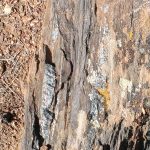
- Some of the folding and high-pressure and temperature indicating cordillerite minerals (dark blue).
-

- Some trail-side purple cacti.
-
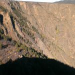
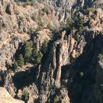
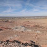
- A view from near the rim of the Black Canyon, looking out at the area outside the canyon.
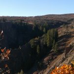
Our first day, we saw the Black Canyon of the Gunnison, a masterpiece of precipitous smoky, crystalline rock cliffs, water carved claws showing us the most ancient of the origins of the Rocky Mountain system.
The Black Canyon of the Gunnison is carved mostly from rocks between 2.0 and 1.4 billion years old, rocks that erupted violently in island arcs, then collided with the western margin of what would become North America, driving themselves deep into the crust and folding them over and over on themselves. Not only are the rocks of the Gunnison important because they are ancient, they also hold a clue as to the formation of continental crust. While oceanic crust is produced by pure mantle melts, continental crust, a more buoyant material, has to be produced iteratively,either through partial melts of the mantle, or through melting of pre-existing crust, each melt first melting the rocks with the lowest melt points. Over time, this leads to lighter, lower melting point rocks. The rocks of the Black Canyon, derived from island arcs in mid-oceanic subduction zones beautifully demonstrate how continental crust can be made and accumulate. This is not to say that, by themselves, the rocks of the Gunnison solve all questions–indeed their positioning raises its own questions.
During the trip, we spent less than a day at less than a mile of elevation above sea level, but many of the rocks we saw were marine in origin. The black rocks of the Gunnison not only represent a partially marine environment, they were metamorphosed and partially melted–typical for materials in the deep crust. The rocks of the Gunnison were likely buried more than thirty kilometers below the earth’s surface, yet today the top of the ancient rocks sit more than two kilometers above sea level. There are two sets of answers–ocean level change, and elevation change of the rocks, caused by mountain building and similar processes. The latter is responsible for the Black Canyon.
How does a modern river cut through some of the highest topography and the hardest rock in an area? Inevitably, this question arises when you see the imposing spires of the Gunnison. While the location of the rock itself poses questions, with its features pointing to a burial of over thirty kilometers at one point, the most striking features of the Black Canyon are its sheer cliffs and its elevation. The rim of the canyon rises above the surrounding landscape, rocks which lie below the rim outside of the canyon obliterated on the rim. The displacement follows a fault more than a billion years old, where it thrusts the canyon above the landscape, a landscape that it has lain below, level with, and on top of. When the present day Rocky Mountains were rising, the crust buckling and bending as it thickened, old weaknesses failed again. Rocks slipped along old breaks, lifting up, down, sliding and making way for the deformation. One of these lifted the rocks of the Gunnison back up. Later, vulcanism encased the landscape, bestowing new topography. It was among these volcanic mounds that the Gunnison river began to flow, etching its way over a low created by the absence of volcanic peaks. The years wore away the soft vulcanic peaks, but it was too late–the river was trapped in the unyeilding path it had carved for itself. The land was still rising and the river bore down. And the newest rocks on top? the ones that made it a low spot? Soft compared to the rock from which the Black Canyon is carved, they melted away.
Day Two:
-

- A photo of the Ancestral Puebloan cliff dwelling known as Balcony House.
-

- A view along one of the canyon-mesa edges
-
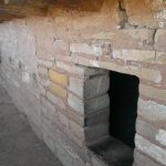
- More detail of Balcony House
-

- Point Lookout and an outcrop
-

- One of the outcrops we examined
-
- One of the canyons in which the cliff houses sit

-

- Spruce Tree House cliff house
-

- A view, from afar, of one of the main portions of Mesa Verde
The next day, we traded our foreboding peaks of black with ribbons of pink for the buttes and near mesas of burnt oranges, pale yellows, and near blacks that make up Mesa Verde. Here we saw sandstones that spoke of desert seas, like today’s Sahara, rivers, coasts, and deep marine environments. In these rocks\ we could read the creation and erosion of two sets of mountains, the anscestral rockies, and the sevier. The rocks themselves, in their enviroments, showed us sea-level changes, and mountain growth. Among the rocks are further treasures–the ruins of the Mesa Verde Anscestral puebloan’s society. Between around 1 AD to 1300 AD, the Anscestral Puebloans called the mesa home, and their homes remain, giving silent testament to their skill and ingenuity. Near perfect masonry, multi-story homes, complex ventilation, and impressive agricultural skill flourished by 1100 AD, and the area was one of the largest settlements in North America.
Day Three:
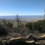
On Tuesday, we spent our day in a desert full of meaning and wonder, fire-colored rocks shedding sediment onto the ground, where it mimicked the same wind-blown dunes that had catagorized the area when the rocks had formed. We learned about the culture of the Diné (the name that the Navajo people give themselves) and desert varnish, a coating of manganese oxide that appears on desert rocks. We looked at the breaking patterns of the rocks to guess at the directions in which stress had been applied to the rocks; we were privileged to glimpse how the desert and these places are sacred to the peoples who live and have lived there. Again we saw evidence for sea-level changes and the uplifts, but truly, when everything began to come together was the next day. There we learned about the interior seaways, vast sand seas. and the Ancestral Rocky Mountains. and while the third day showed us more of the origin of the more familiar parts of the Rocky Mountain system: those parts which arose no earlier than 90 million years ago. The fire-tinged rocks amid the desert, whose life showed itself in the green of sparse plants and the plentitudes of tracks awed us in Monument and Mystery Valleys, where too we learned more of the history of the indigenous peoples.
Day Four:
-
- A view from near the grand canyon, where we pulled off to talk about the Triassic, in one of our last opportunities to see rocks from the Triassic.
-
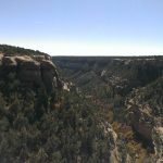
- View from a south rim overlook

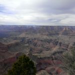
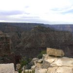
On our fourth day, we arrived at the Grand Canyon, our first of two days there. While all our days were spectacular, the sheer scale of the Grand Canyon, even from the rim, as we saw it the first day, is unrivaled. Rim to rim, the average width is ten miles, as we found out after making bets on the distance at a particular point. The very oldest rocks in the Grand Canyon are between 2.0 and 1.7 billion years old, while the youngest we saw were around 270 million years old. In the park, there are, igneous caps of rock as young as 10 million years. The grand canyon’s average depth is 1.6 kilometers, its time span as much as 1.6 billion years, even without the newest, igneous rocks, though nearly half of that time is not represented in any rock in the canyon.
Day 5:


-

- Indian Point, where we ate lunch.

For our second day in the Grand Canyon, we hiked four and a half miles, each way, of the bright angel trail, descending roughly halfway. We spent time examining the stratigraphy and we saw the faults and folds that testified to the multiple mountain ranges the rocks had seen built. We saw temporal equivalents of rocks we had seen before, and filled in other missing spots. We saw the canyon, teeming with life, and we found companionship while we learned and hiked.
On the way back up, I measured our progress by counting off rock formations and, for a time, followed a bushtit, a small grey bird, that hopped across each switchback at my approach, only to reappear on the other side. I reached the top tired but exhuberant, and celebrated with ice cream, with my classmates, who arrived, as I had, in twos and threes.
We all ate together that night, most of us fatigued but happy, and ready for our final day of field work.
Day Six:
While I, at least, was not ready for the end of the field days, I was ready for the San Francisco Volcano fields, our last stop, and also the youngest. The San Francisco Volcano Fields were formed just after the bulk of the Rocky Mountains and remained active until recently. Here we saw the ending of the Rocky Mountain system and its long term ramifications in cindercones, shield volcanoes, and stratovolcanos, with the youngest eruptions as recent as 1000 years ago. We stood in the inside of an eroded cindercone and walked on the broken lava flows of mere thousands of years ago. Then, too soon, it was time for us to drive to our final stop–a hotel for the night.
That night, many of us stayed up late,

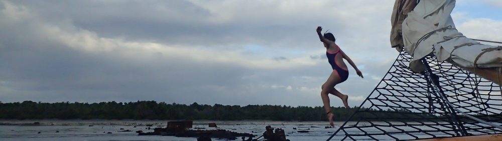
Clockwise: Me on days one (photo by Stephanie Widzowski), two (photo by Jake Bernstein), four (photo by Emily Kampmeyer), and five (photo by Erina Kironde).
laughing, talking, even singing as we celebrated a wonderful trip. While we went to learn, and learn we did, we also formed new and stronger friendships and saw around us the incredible majesty of life, both human and non-human, amidst wondrous sculptures of rock. We were surrounded, always, by the vast, the monumental, the incredible, and yet always we had levity and companionship. We learned of the intimate connections between the presences of vast continetal seas and explosive vulcanism and we made jokes about the rocks we saw. We exchanged ideas and shared friendship, both of which continue, even with our trip over.
Hey Amelia! I like your blog 🙂 I was just accepted ED to the class of 2022 and am considering mathematics as a major. Could I ask you some questions about it?
Absolutely! You can ask here or by emailing me at amccarthy@brynmawr.edu.